


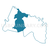
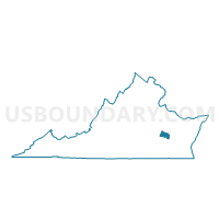
Precinct 2-1, Charles City County, Virginia
About
Outline

Summary
| Unique Area Identifier | 681275 |
| Name | Precinct 2-1 |
| County | Charles City County |
| State | Virginia |
| Area (square miles) | 44.05 |
| Land Area (square miles) | 42.26 |
| Water Area (square miles) | 1.79 |
| % of Land Area | 95.94 |
| % of Water Area | 4.06 |
| Latitude of the Internal Point | 37.38333010 |
| Longtitude of the Internal Point | -77.11990950 |
Maps

Graphs
Select a template below for downloading or customizing gragh for Precinct 2-1, Charles City County, Virginia


Neighbors
Neighoring Voting District (by Name) Neighboring Voting District on the Map
- Airport Voting District, New Kent County, VA
- Brandon Voting District, Prince George County, VA
- Chickahominy River Voting District, New Kent County, VA
- Precinct 1-1, Charles City County, VA
- Precinct 3-1, Charles City County, VA
Top 10 Neighboring County Subdivision (by Population) Neighboring County Subdivision on the Map
- District 4, New Kent County, VA (2,921)
- District 1, Charles City County, VA (2,561)
- District 3, Charles City County, VA (2,435)
- District 2, Charles City County, VA (2,260)
- Brandon district, Prince George County, VA (1,361)
Top 10 Neighboring Place (by Population) Neighboring Place on the Map
Top 10 Neighboring Unified School District (by Population) Neighboring Unified School District on the Map
- Prince George County Public Schools, VA (35,725)
- New Kent County Public Schools, VA (18,429)
- Charles City County Public Schools, VA (7,256)
Top 10 Neighboring State Legislative District Lower Chamber (by Population) Neighboring State Legislative District Lower Chamber on the Map
- State House District 97, VA (87,705)
- State House District 74, VA (80,153)
- State House District 62, VA (76,461)
Top 10 Neighboring State Legislative District Upper Chamber (by Population) Neighboring State Legislative District Upper Chamber on the Map
- State Senate District 3, VA (211,723)
- State Senate District 9, VA (201,994)
- State Senate District 13, VA (197,229)
Top 10 Neighboring 111th Congressional District (by Population) Neighboring 111th Congressional District on the Map
Top 10 Neighboring Census Tract (by Population) Neighboring Census Tract on the Map
- Census Tract 7003, New Kent County, VA (8,318)
- Census Tract 7001, New Kent County, VA (5,734)
- Census Tract 8504, Prince George County, VA (5,182)
- Census Tract 7002, New Kent County, VA (4,377)
- Census Tract 6001, Charles City County, VA (2,726)
- Census Tract 6002, Charles City County, VA (2,338)
- Census Tract 6003, Charles City County, VA (2,192)